From orbit to canopy to water.
Saraqube fuses satellite, drone and LiDAR data into locally-calibrated environmental intelligence for Borneo - accurate maps, water-quality monitoring and blue-carbon insight you can act on.
Built on a decade of Borneo research.
Saraqube Sdn. Bhd. is a Sarawak digital-environmental technology company - a spin-off from the SDEC Technology Accelerator (Cohort 1, 2022), incorporated in October 2023 and founded by three researchers from Swinburne Sarawak and UNIMAS. We deliver peer-reviewed science and policy-grade reporting, not just software, to agencies, industry and communities across Borneo.
Science first
Peer-reviewed methods - like our semi-analytical TSS & DOC models for Sarawak's peatland-influenced waters (Cherukuru et al., Remote Sensing, 2021).
Local calibration truth
Drone, LiDAR and hyperspectral ground truth collected here in Sarawak - not generic global satellite models.
Talent development
PhD & MSc exchanges with CSIRO, UQ scholarships and outreach across Sarawak - every project grows local Earth-observation talent.
The full sensing spectrum.
One platform, from orbit to canopy to water - land and water together.
Satellite
Sentinel-1/2 · MODIS · Pléiades-Neo 30 cm · Pixxel hyperspectral - extent, change and water quality at scale.
Airborne
Drone RGB / RTK photogrammetry and LiDAR - canopy structure, height and biomass at centimetre detail.
Field & hyperspectral
ASD & HydraSpectra spectroradiometers - the calibration truth and spectral libraries our models are built on.
Analytics
Machine learning, Open DataCube and cloud (GEE) pipelines - turning multi-sensor data into models, dashboards and decisions.
Not just maps - dashboards agencies can operate.
Our decision-support dashboards turn multi-sensor data into monitoring your team runs itself - repeatable every quarter, not a one-off survey.
- Extent & area - Nipah, mangrove and water, accurately mapped
- Canopy height & biomass from LiDAR structure
- Condition & vigour - time-series stress alerts
- Tidal suitability & multi-year change
EnviMon Live
Our environmental-monitoring web app - explore coastal maps and monitoring insights for Sarawak in the browser.
Open EnviMonAquaWatch Sarawak Under development
Real-time water intelligence with CSIRO at the Kuching Wetlands National Park - DOC, CDOM, FDOM and more, from in-situ hyperspectral sensors to Sentinel-2. Launching soon.
CrocWatch Under development
Telemetry dashboard for estuarine crocodiles (Crocodylus porosus) in Kuching Wetlands National Park - movements, behaviour states, tides and proximity to people and aquaculture, on one map for park managers. Launching soon.
Work that's already in the field.
Delivered studies, live pilots and a decade of research behind them.
FCDO-funded mangrove study - Sabah, Sarawak & Brunei
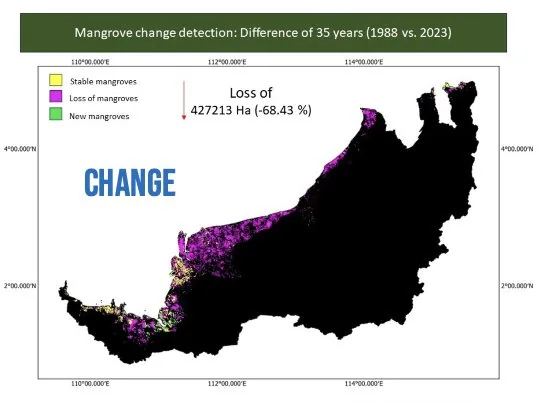
"Mangrove forests in Malaysia (Sabah, Sarawak) and Brunei: A comparative study" - a regional evidence base spanning 30+ years of mangrove distribution, an assessment of ecosystem services, deforestation drivers, community engagement and conservation trade-offs. Published Oct 2024 · Evidence Fund · DOI 10.53832/evidence-fund.0131.
Read the studyBelawai program
Accurate mapping of Sarawak's Nipah (Nypa fruticans) - the gula apong economy - with ground carbon measured and fused Sentinel, Pléiades-Neo, Pixxel hyperspectral, drone and LiDAR data. Launching soon.
The Sarawak DataCube
18 years of satellite ocean-colour records analysed for Sarawak's peatland-influenced coastal waters - with localised, peer-reviewed bio-optical models retrieving TSS, CDOM, chlorophyll-a and dissolved organic carbon (Cherukuru et al., Remote Sensing, 2021).
 Restricted
Three researchers. One decade of Borneo data.
Prof. Moritz Mueller
Swinburne Sarawak · Coastal remote sensing & carbon
Assoc. Prof. Aazani Mujahid
UNIMAS · Marine science & biogeochemistry
Assoc. Prof. Jacey Lynn Minoi
UNIMAS · AI & machine learning
Let's map what matters.
Planning a blue-carbon or MRV project, managing a resource that needs repeatable monitoring, or keen to collaborate on research? Let's pilot it on your priority landscape.
Email us